 Pithoro
Kandhra
Sultan Kot
Rahimabad
Mithiani
New Jatoi
Ratanabad
Bhaledino Kaka
Arija
Pithoro
Kandhra
Sultan Kot
Rahimabad
Mithiani
New Jatoi
Ratanabad
Bhaledino Kaka
Arija
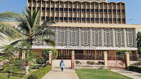
National Museum Of Pakistan on the map, Karachi, Pakistan
Photo
Where is located National Museum Of Pakistan
National Museum Of Pakistan — local attraction, which is located at Shahrah-e-Kemal Ataturk, Saddar Karachi, Karachi City, Sindh 75500, Pakistan and belongs to the category — national museum. Average visitor rating for this place — 4.3 (according to 1043 ratings, information from open sources and relevant for 2022).
Exact location — National Museum Of Pakistan, marked on the map with a red marker.
You can get directions to National Museum Of Pakistan on the map from your location.
What else is interesting in Karachi? You can see all the sights if you go to the city page.
Coordinates
National Museum Of Pakistan, Pakistan coordinates in decimal format: latitude — 24.85281227547024, longitude — 67.01788062455208. When converted to degrees, minutes, seconds National Museum Of Pakistan has the following coordinates: 24°51′10.12 north latitude and 67°1′4.37 east longitude.
Nearby cities
The largest cities that are located nearby:
- Hyderabad — 147 km
- Tando Allahyar — 183 km
- Tando Ādam — 193 km
- Nawabshah — 207 km
- Mīrpur Khās — 213 km
- Dādu — 221 km
- Larkana — 321 km
- Bhuj
 (India) — 324 km
 - Khairpur — 341 km
- Sukkur — 362 km
- Gandhidham (India) — 374 km
- Shikarpur — 377 km
- Jacobabad — 403 km
- Jamnagar (India) — 408 km
- Rajkot (India) — 480 km
- Sadiqabad — 488 km
- Gondal (India) — 503 km
- Junagadh (India) — 512 km
- Khanpur — 548 km
Distance to the capital
Distance to the capital (Islamabad) is about — 1149 km.