
 Warner Robins
Wantagh
Bethel
Misty Hill Farm
United States
Wakonda Beach (R33) Airport
Wilmington
Poland
Miami International Airport
Warner Robins
Wantagh
Bethel
Misty Hill Farm
United States
Wakonda Beach (R33) Airport
Wilmington
Poland
Miami International Airport
Village Creek State Park on the map, Beaumont, United States
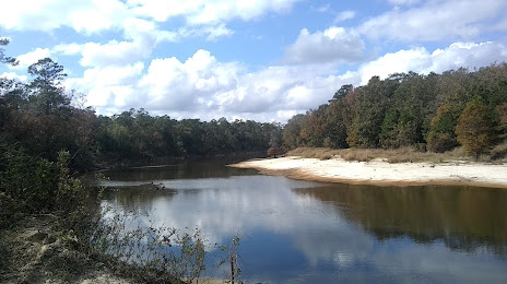
Photo
Where is located Village Creek State Park
Village Creek State Park — local attraction, which is located at 8854 Park Rd 74, Lumberton, TX 77657, United States and belongs to the category — state park. Average visitor rating for this place — 4.2 (according to 316 ratings, information from open sources and relevant for 2022).
Exact location — Village Creek State Park, marked on the map with a red marker.
You can get directions to Village Creek State Park on the map from your location.
What else is interesting in Beaumont? You can see all the sights if you go to the city page.
Coordinates
Village Creek State Park, United States coordinates in decimal format: latitude — 30.250636376314752, longitude — -94.1787732253306. When converted to degrees, minutes, seconds Village Creek State Park has the following coordinates: 30°15′2.29 north latitude and -94°10′43.58 east longitude.
Nearby cities
The largest cities that are located nearby:
- Houston — 124 km
- Lafayette — 202 km
- Shreveport — 273 km
- Baton Rouge — 288 km
- Waco — 328 km
- Austin — 346 km
- Killeen — 360 km
- Mesquite — 376 km
- Metairie — 381 km
- Dallas — 388 km
- New Orleans — 389 km
- Garland — 390 km
- Grand Prairie — 398 km
- Richardson — 399 km
- Irving — 400 km
- Plano — 403 km
- Arlington — 404 km
- Corpus Christi — 407 km
- Carrollton — 410 km
Distance to the capital
Distance to the capital (Washington) is about — 1837 km.