
 Pointe-à-la-Croix
Sainte-Irène, Quebec
Marsoui
Hecla
Muskrat Dam
Wunnummin Lake
Sainte-Brigitte-de-Laval
Drayton
Mauricie
Pointe-à-la-Croix
Sainte-Irène, Quebec
Marsoui
Hecla
Muskrat Dam
Wunnummin Lake
Sainte-Brigitte-de-Laval
Drayton
Mauricie
Chute du Diable on the map, Shawinigan, Canada
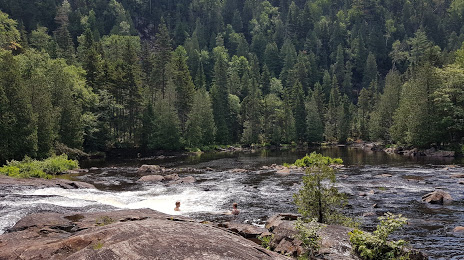
Photo
Where is located Chute du Diable
Chute du Diable — local attraction, which is located at Quebec and belongs to the category — -. Average visitor rating for this place — 4.9 (according to 16 ratings, information from open sources and relevant for 2022).
Exact location — Chute du Diable, marked on the map with a red marker.
You can get directions to Chute du Diable on the map from your location.
What else is interesting in Shawinigan? You can see all the sights if you go to the city page.
Coordinates
Chute du Diable, Canada coordinates in decimal format: latitude — 46.71147486128128, longitude — -72.88130848577185. When converted to degrees, minutes, seconds Chute du Diable has the following coordinates: 46°42′41.31 north latitude and -72°52′52.71 east longitude.
Nearby cities
The largest cities that are located nearby:
- Trois-Rivières — 29 km
- Levis — 115 km
- Quebec — 117 km
- Longueuil — 128 km
- Laval — 130 km
- Montreal — 133 km
- Sherbrooke — 145 km
- Saguenay — 240 km
- Gatineau — 259 km
- Kingston — 393 km
- Manchester
 (United States) — 408 km
 - Lowell (United States) — 450 km
- Amherst (United States) — 467 km
- Syracuse (United States) — 476 km
- Worcester (United States) — 482 km
- Cambridge (United States) — 482 km
- Boston (United States) — 485 km
- Springfield (United States) — 493 km
- Hartford (United States) — 531 km
Distance to the capital
Distance to the capital (Ottawa) is about — 260 km.