
 Pointe-à-la-Croix
Sainte-Irène, Quebec
Marsoui
Hecla
Muskrat Dam
Wunnummin Lake
Sainte-Brigitte-de-Laval
Drayton
Mauricie
Pointe-à-la-Croix
Sainte-Irène, Quebec
Marsoui
Hecla
Muskrat Dam
Wunnummin Lake
Sainte-Brigitte-de-Laval
Drayton
Mauricie
Église Saint-Patrice on the map, Rivière-du-Loup, Canada
Photo
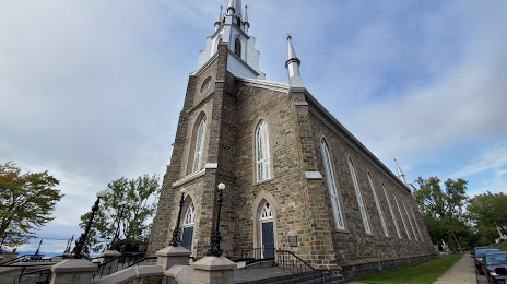
Where is located Église Saint-Patrice
Église Saint-Patrice — local attraction, which is located at 121 Rue Lafontaine, Rivière-du-Loup, QC G5R 3A3, Canada and belongs to the category — catholic church. Average visitor rating for this place — 4.4 (according to 27 ratings, information from open sources and relevant for 2022).
Exact location — Église Saint-Patrice, marked on the map with a red marker.
You can get directions to Église Saint-Patrice on the map from your location.
What else is interesting in Rivière-du-Loup? You can see all the sights if you go to the city page.
Coordinates
Église Saint-Patrice, Canada coordinates in decimal format: latitude — 47.837944815072646, longitude — -69.53823210183654. When converted to degrees, minutes, seconds Église Saint-Patrice has the following coordinates: 47°50′16.6 north latitude and -69°32′17.64 east longitude.
Nearby cities
The largest cities that are located nearby:
- Saguenay — 130 km
- Quebec — 172 km
- Levis — 178 km
- Trois-Rivières — 283 km
- Sherbrooke — 325 km
- Longueuil — 399 km
- Montreal — 405 km
- Laval — 406 km
- Gatineau — 545 km
- Manchester
 (United States) — 557 km
 - Dartmouth — 586 km
- Halifax — 587 km
- Lowell (United States) — 593 km
- Cambridge (United States) — 617 km
- Boston (United States) — 618 km
- Worcester (United States) — 643 km
- Amherst (United States) — 654 km
- Kingston — 680 km
- Springfield (United States) — 682 km
Distance to the capital
Distance to the capital (Ottawa) is about — 542 km.